


By: John Clements
Homeland Defense in the Pacific
Of all the Geographic Combatant Commands (GCCs), two have a Homeland Defense mission. The United States Northern Command (USNORTHCOM) has the lion’s share of the responsibility. Their area of responsibility (AOR) covers the 48 contiguous states, Alaska, and the U.S. Caribbean territories. The U.S. Indo-Pacific Command (USINDOPACOM) has the other Homeland Defense mission and is responsible for Hawaii, Guam, American Samoa, the Commonwealth of the Northern Marianas Island (CNMI), and several uninhabited islands. Additionally, three nations in a “Compact of Free Association” with the United States fall under the Homeland Defense mission in the Pacific—The Republic of Palau, the Federated States of Micronesia, and the Republic of the Marshall Islands. The distance from the Hawaiian Island of Oahu to Guam is 3,800 miles. This is 1,400 miles more than the distance from Los Angeles to New York. The distance from Oahu to the Los Angeles on the mainland is 2,600 miles. These vast distances create a problem set known to USINDOPACOM as “The Tyranny of Distance,” which applies to all operations in their AOR.
Figure 1 shows a map of Oceania, with U.S. possessions outlined and distances from other U.S. territories overlayed [1].
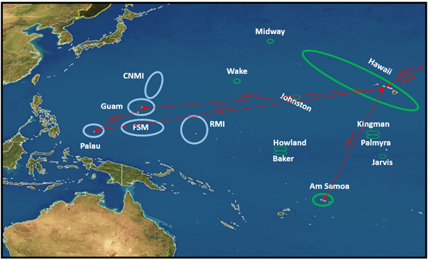
Figure 1: USINDOPACOM Homeland Defense AOR [1].
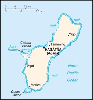
Figure 2: Guam (Left) Is Just South of the Northern Mariana Islands (Right) [2].
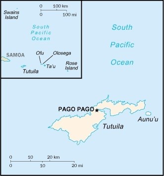
Figure 3: Tutuila Island, With American Samoa Inset [2].
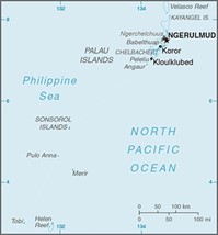
Figure 4: Palau (Left) and the Federated States of Micronesia (Right) [2].
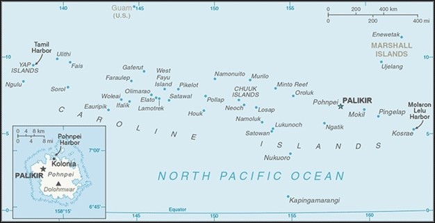
Figure 5: Republic of the Marshall Islands [2].
Weapons of Mass Destruction
A WMD is defined by U.S. law as any of the following:
- A destructive device, such as an explosive or incendiary bomb, rocket, or grenade;
- A weapon that is designed to cause death or serious injury through toxic or poisonous chemicals;
- A weapon that contains a biological agent or toxin; or
- A weapon that is designed to release dangerous levels of radiation or radioactivity [3].
Chemical, biological, radiological, and nuclear (CBRN) threats pose some of the most difficult challenges regarding detection, remediation, disposal, protection of the population, and logistical needs. Unlike a conventional explosive device, CBRN threats may persist in the affected area for hours, days, weeks, and in the case of certain isotopes, thousands of years [4]. We will focus on the unique challenges posed by CBRN threats.
A major limitation for any adversary is the delivery method. An explosive means of dispersing a CBRN agent may destroy the agent, particularly a chemical or biological threat. Other dispersal methods, such as sprayers and human vectors, are dangerous for the personnel involved. The viscosity of many chemical agents hinders spraying. However, adversaries are continually refining methods of producing and delivering chemical and biological agents. There is also a danger of being covertly supplied by a state actor with developed capabilities.
Geography and Infrastructure
The vast distances across the Pacific Ocean pose difficulties for any response effort. A commercial flight from Honolulu, HI, to Hagåtña, Guam, is nearly 8 hours. Supplies must be gathered, packaged, and loaded onto any flight, and then the reverse done on the receiving end. On the receiving end, there must be representatives from the local government ready to identify the needs of the community so that the response is tailored to the actual need. This will require local responders to be trained on incident command procedures.
Each island has a unique situation regarding transportation to and from the island. Table 1 lists several inhabited islands and particular attributes of that island. Focusing on the logistical issues, this table provides data on seaports, airports, and medical facilities. Many islands have no actual medical facilities but are served by a clinic. Citizens of many islands must be evacuated to higher echelons of care even for nonlife-threatening issues because the local hospital or clinic lacks something as commonplace as an X-ray machine.
Table 1: Air and Seaports in the Pacific [5–7]
| Island | Airport
(IATA Code) |
Max Runway Length (ft) | Seaport | Seaport Size | Island Population (Estimate) | Area in sq mi (sq km) | Total Hospital Beds |
| Tutuila, AS | Pago Pago-Tafuna Int’l (PPG) | 10,000 | Pago Pago Harbor | Small | <50,000 | 142 (55) | 128 |
| Ofu and Olosega, AS | Ofu (OFU) | 2,000 | None | N/A | 500 | 2 (5.2) | Clinic space only |
| Aunu’u, AS | None | N/A | None | N/A | 430 | .59 (1.5) | None |
| Tau, AS | Fitiuta Airport (FTI) | 3,190 | None | N/A | 730 | 17 (44) | |
| Saipan, CNMI | Saipan Int’l Airport (SPN) | 8,700 | Saipan | Small | 47,500 | 46 (119) | 86 |
| Tinian, CNMI | Tinian Int’l Airport (TIQ) | 8,600 | Tinian | Very small | 3,540 | 39 (101) | 5 (clinic) |
| Rota, CNMI | Rota Int’l Airport (ROP) | 6,000 | Rota | Very small | 2,500 | 33 (85) | 10 (clinic) |
| Guam | Andersen AFB (UAM)
Antonio B. Won Pat Int’l (GUM) |
11,185
10,015 |
Apra Harbor | Medium | 167,000 | 210 (540) | 198 (Guam Memorial Hospital)
42 (Naval Hospital Guam) |
| Oahu, HI | Honolulu Int’l (HNL)
Dillingham Airfield (HDH)
|
12,300
9,007 |
Honolulu | Medium | 976,000 | 597 (1545) | >1,600 (not including military hospitals) |
| Hawaii, HI (The Big Island) | Kona Int’l (KOA)
Hilo Int’l Airport (ITO) |
9,800
11,000 |
Hilo | Medium | 187,000 | 4,028 (10,430) | 225 |
| Maui, HI | Kahalui Airport | 6,995 | Kahului | Very small | 167,400 | 727 (1,883) | 219 |
| Kauai, HI | Lihue Airport (LIH) | 6,500 | Nawiliwili Bay | Small | 7,300 | 562 (1,456) | 72 |
| Moloka’I, HI | Moloka’I Int’l Airport (MKK) | 4,494 | Kaunakakai Harbor | Very small | 7,300 | 260 (670) | 15 |
| Lanai, HI | Lanai Airport | 5,001 | Kaunalapau Harbor | Very small | 3,100 | 141 (364) | 14 |
| Ni’ihau, HI | None | None | 170 | 70 (180) | None | ||
| Oreor, Ngerekebesang, Babelthuap, and Malakal Islands (connected by a road), PU | Babelthuap Airport (ROR) | 7,200 | Malakal Harbor | Very small | 16,700 (combined) | 128 (331) | 80 |
| Peleliu, PU | Peleliu Airport (C23) | 6,000 | None | N/A | 500 | 5 (13) | 0 |
| Angaur, PU | Angaur Airstrip (ANG) | 7,000 | None | N/A | 130 | 3 (8) | 0 |
| Yap Main Islands, FSM | Yap International Airport (TYA) | 6,000 | Colonia | Very small | 11,400 | 39 (100) | |
| Pohnpei, FSM | Pohnpei Int’l Airport (TPN) | 6,600 | Pohnpei Harbor | Small | 36,200 | 129 (334) | |
| Kosrae, RMI | Kosrae Airport (TSA) | 5,752 | Lele Harbor | Very small | 6,600 | 43 (111) | |
| Chuuk Lagoona, RMI | Chuuk Int’l Airport (TKK) | 6,013 | Moen | Very small | 36,100 | 36 (93) | 120 |
| Majuro, RMI | Amata Kabua Int’l Airport (KMJ) | 7,913 | Majuro Atoll | Very small | 27,800 | 3.75 (9.7) | 101 |
| Kwajalein, RMI | Bucholz Army Airfield (KWA) | 6,668 | Kwajalein | Very small | 11,400 | 6.33 (16.4) | 45 |
| aChuuk Lagoon is several islands/islets surrounding a lagoon.
Notes: IATA = International Air Transport Association, AS = American Samoa, CNMI = Commonwealth of the Northern Mariana Islands, HI = Hawaii, PU = Palau, FSM = Federated States of Micronesia, and RMI = Republic of the Marshall Islands. |
|||||||
Emergency material stockpiles will deplete quickly. Critically, many of the islands will need to have additional materials brought to them by air. The length of the runway is one marker for the quantity of supplies which could be delivered by air. Certainly, other aspects must be considered, such as maintenance facilities, equipment for off-load and transport, and fuel storage. The ports of most islands are listed as “small” or “very small” according to the World Port Index. Only the largest three islands with a port are listed as “medium.” Despite their reliance on the sea, no islands have a “large” port. This will limit the size and type of ship that can be accommodated. The number of hospital beds available is one indicator of an area’s ability to respond to a WMD crisis. The smaller islands are only served by clinics with few or no bedspaces.
Population figures only tell part of the story. Tourism is the primary commercial activity on virtually every island. According to the Hawaii Tourism Authority, Oahu sees around a half million tourists each month, and Maui sees a quarter million [8]. CNMI saw an average of 40,000 tourists each month in 2019 [9]. With a population of under 60,000, CNMI could easily have a scenario where 20–25% of the people on the island are tourists. Pacific islands draw most of their tourism from Asia. Language barriers complicate the response further in an already confusing and chaotic time.
The trade winds, which normally blow east-to-west in the Northern Hemisphere, are one major benefit of the islands. Any release of radiation, chemicals, or an airborne biological hazard such as anthrax would most likely be blown out to sea relatively quickly [10].
Personal Protective Equipment (PPE)
PPE will be needed for responders and civilians alike. Any PPE stored locally will be depleted quickly. It would be impossible to expect each island to have enough PPE available for each different type of incident. Breathing protection is critical to combat all CBRN weapons.
Many of the islands are underequipped. For example, Palau has received several grants for fire trucks and other emergency equipment from Japan [11]. These relatively small grants have significantly enhanced Palauan response capabilities. Even with these grants, Palau has little PPE stocks to protect its first responders or citizens.
Prepositioned stocks are critical to any WMD response. Protective equipment, medical supplies, clean water, and fuel must be quickly accessible to responders. There are virtually no propositioned stocks on any of the referenced islands except for Guam and Oahu. Most of the stockpiled equipment will focus on consequence management and protective equipment for responders but not for the population.
Evacuation or Shelter-in-Place
The evacuation of the civil population may become a necessity after an attack. A CBRN attack carries unique considerations due to the persistence of the threat and the fact that people, equipment, and even personal belongings could unknowingly carry chemical agents, biological hazards, and radiological material. In the moments immediately after an attack, many civilians will likely evacuate or flee the area prior to any response by local civil authorities. Unfortunately, this could mean the transfer of the threat to a wider area.
Sheltering in place is the best option to mitigate the effects of many attacks. Staying inside, shutting windows and doors, and sealing any gaps, such as exhaust fans, are effective against alpha- and beta-emitting ionizing radiation and trace amounts of chemical vapor. The three principles of protection from ionizing radiation are “time, distance, and shielding.” Sheltering-in-place can provide both distance and shielding from radioactive particles. Figure 6 shows the penetrating distances of ionizing radiation based on different materials.
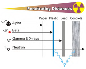
Figure 6: Ionizing Radiation Penetration [12].
The Federal Emergency Management Agency states that “In most cases…hazardous chemicals are dispersed with increasing distance from the source” [13]. Identifying safe areas for refuge could be a tall order on smaller islands. Depending on conditions, the entire surface area of an island could be in the contaminated zone in under an hour. Figure 7 shows the spread of radiation after a hypothetical release in Washington, D.C. The diameter of the cloud is roughly 2 miles.
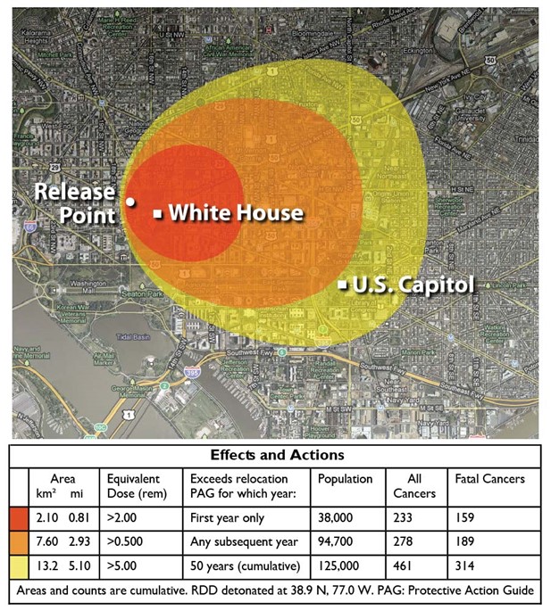
Figure 7: Hypothetical Attack on Washington D.C. With 50 g of Cesium-137 Chloride [14].
The geography and topography of an impacted island will have a major effect on the types of actions that need to occur. In the chemical and radiological realms, wind can carry energized particles and chemical vapors over great distances. Islands in the Pacific are uniquely affected by trade winds, causing rapid movement of contamination. Imposed over Washington, D.C., the hypothetical attack in Figure 7 accounted for 7 mile-per-hour winds. The constant wind speed in the Pacific islands of concern is normally double that. Many islands, such as Oahu, Hawaii, Guam, Saipan, Ofu, and Olosega, are bisected by mountains. These mountains will help to contain a threat closer to the incident site. Responders must understand how these factors will impact a response [15]. On a relatively flat island or on the western side of an island, sheltering-in-place will be the preferred option to protect the population. However, on the eastern side of an island, provided that is the origin of the incident and the topography will contain some of the contamination, evacuation may be necessary.
Evacuations must be done in a controlled, safe manner. Initially, these evacuations will be conducted by local officials. But this creates an immediate issue for many areas in the Pacific—where does everyone go? Eight of the populated islands previously listed are smaller in area than Washington, D.C. While their populations are generally smaller, this gives limited space to evacuate to in the event of an attack. A large percentage of the island could be rendered untenable by the attack. Areas need to be set up to marshal, test, decontaminate, track, and care for people. Decontamination areas must be kept upwind, and their waste segregated.
Evacuations are inherently dangerous. They create panic and can cause unnecessary stress to families and officials if the evacuation itself is not necessary. The elderly, disabled, and hospitalized are at increased risk during evacuation. They are also resource intensive. People need fuel, food, fresh water, hygiene supplies, power, medication, and clothing while traveling and when they reach their destination. Ordering an evacuation is always a risk-based decision, and it may not be an option in many locations in the Pacific. For example, evacuation was avoided during the Three Mile Island Nuclear Reactor partial meltdown. Pennsylvania Governor Dick Thornburgh did not order a general evacuation because of the risk it posed and the panic that would ensue. He determined that evacuation could lead to many deaths. Some of the elderly and hospitalized would not survive the physical and mental stress. The increase in traffic, combined with the desire to move quickly, could create more traffic fatalities. Notably, Governor Thornburgh himself remained in Harrisburg, just 12 miles away [16]. Sheltering-in-place will be the most viable option for all but the most catastrophic of scenarios.
Conclusions
The United States has a Homeland Defense commitment in the Pacific Ocean that stretches over 4,000 miles. There are unique technical and logistics challenges in managing a response to these islands that do not exist in the Continental United States. Many of the islands are sparsely populated. While this reduces the impact of an event, it also reduces the availability of a local response to nearly zero. As the entire U.S. Department of Defense looks westward, they must consider the over 1.5 million inhabitants of these islands and be prepared to respond at a moment’s notice.
References
- United States Indo-Pacific Command J57. “Homeland Defense 101,” 17 March 2021.
- Central Intelligence Agency. “The World Factbook.” https://www.cia.gov/the-world-actbook/maps/, accessed 20 April 2021.
- Federal Bureau of Investigation. “What We Investigate: Weapons of Mass Destruction.” https:// www.fbi.gov/investigate/wmd, accessed 10 April 2021.
- Frey, J., CPT. “Intro to Rad Safety.” U.S. Army, February 2016.
- http://www.airnav.com, accessed 8–14 April 2021.
- National Geospatial-Intelligence Agency. World Port Index: Twenty-Seventh Edition. 2019.
- Rural Health Information Hub. “Pacific Territories, Commonwealth, and Freely Associated States.” https://www.ruralhealthinfo.org/states/pacific-territories, accessed 8–14 April 2021.
- Hawaii Travel Guide. “Hawaii Tourism Statistics.” https://www.hawaii-guide.com/hawaii-tourism-statistics#:~:text=Oahu%20Visitor%20Data,the%20other%20islands%20arrival%20data, accessed 14 April 2021.
- Marianas Visitors Authority. “MVA Arrival Statistics FY 2020.” https://www.mymarianas.com/press-release-reports/, accessed 15 April 2021.
- Florida Atlantic University – Center for Environmental Studies. “Climate Science Investigations: Global Wind Patterns.” http://www.ces.fau.edu/nasa/content/resources/global-wind-patterns.php, accessed 6 May 2021.
- Office of the Public Auditor, Republic of Palau. “Performance Audit Report on Japan Grant Assistance for Grassroots Human Security Projects.” http://palauopa.org/pdf/opa-audits/Year% 202017/JP-Fire-Trucks-Angaur-State.pdf, accessed 20 April 2021.
- Frey, J., CPT. “Physical Principle of Ionizing Radiation.” MEIR Course, AFRRI, in Introduction to Radiation Safety,S. Army Public Health Command, November 2012.
- Federal Emergency Management Agency. “Organizational Emergency Response: Chapter 10.” https://training.fema.gov/hiedu/docs/fem/chapter%2010%20-%20organizational%20emergency %20response.doc, accessed 25 April 2021.
- Medalia, J. “‘Dirty Bombs’: Background in Brief.” Congressional Research Service, 24 June 2011.
- United States Army Pacific Consequence Management Branch. Personal communication, 27 April 2021.
- Rockwell, T. “Facts & Fission.” Mechanical Engineering, vol. 131, no. 12, pp. 32–37, 2009.